|  | |
 |
|  |
 |  | |
| | |
|
| |
| | |
|
|
FINN'S POINT or Pompion's Hook or Fort Mott.
PEDRICKTOWN
PILESGROVE
PENN'S NECK
WISTARBURG
FRIESBURG Founded 1748 near Alloway by Germans who
had worked in Wistar's Glass Works.
Points of interest:
DARETOWN
QUINTON'S BRIDGE
WOODSTOWN
From Historic Roadsides of New Jersey by The Society of Colonial Wars in the State of New Jersey, 1928
Edited by GET NJ, COPYRIGHT 2002
Salem County was a part of the land embraced in Fenwick's Colony which extended from Oldman's Creek to Cohan,
sick or Cohansey Creek. It was originally settled by a company
of English from New Haven, Connecticut, under the leadership
of Theophilus Eaton. The settlement, made on the farm known
as the Amos Harris Farm at the mouth of Salem Creek, did
not last long. The next settlement was at Fort Elfsborg, which
was built about March 1, 1642-43, on the eastern Bank of
Salem River near its mouth. This fort, constructed by Swedes
under Governor Printz, was commanded by Sven Skute. Subsequently it became untenable because of mosquitoes and was
called Myggenborg, the "Mosquito Fort."
CARNEY'S POINT
A Dutch settlement antedating Fenwick. The Indian Deed to Fop. Janssen Outhout, dated 1664-5,
is still on record.
Settled
early and first called Finn's Town Hook.
named for Rodger Pedrick, whose one
thousand acres was surveyed June 17, 1682.
Named for Thomas Pile, whose ten thousand acres was laid out to him in 1682.
Thirty-two, thousand acres set off to
William Penn in 1706.
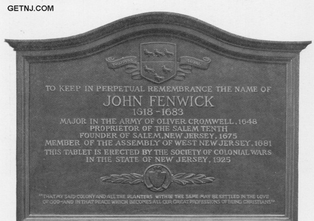
FENWICK GROVE
Upper Mannington, home of John
Fenwick, who lived, died, and is buried there. Marked by
monument erected July 4, 1924, on Highway from Salem to
Woodstown.
Two miles east of Alloway. Site of the
Glass Works of Casper Wistar, whose factory was built 1739.
PITTSGROVE or Champney Corner, commonly called Pole
Tavern.
Eastern boundary of Fenwick. The first regularly
equipped military organization for defense with barracks or
ganized there. The barracks are still standing. The volunteer
company formed was officered by Captain Jacob duBois and
Lieutenant Peter duBois, who, together with many privates of
the same name, were descendants of Louis duBois, a Huguenot,
who settled in New Paltz, New York, in 1660.
Taken from the Italians by Napoleon Bonaparte in his
second campaign in Italy, afterward captured from the
French by the Duke of Wellington in the Spanish Peninsula campaign; later taken from the British at Lundy's
Lane by General Scott; finally rendering service in the
Mexican War and returning with Colonel Dickinson to
his home in Salem County, New Jersey.
Two miles below Pole Tavern. Here stands
the ancient brick church built in 1740, called the Pittsgrove
Presbyterian Church. It was built on land obtained from Louis
duBois, who with his brother, Barent duBois, emigrated from
New Paltz, New York, to Pittsgrove Township, purchased in
1714 by their father, Jacob duBois, son of Louis duBois, the
Huguenot, from Daniel Cox of Burlington, New Jersey.
The graveyard contains the remains of many Revolutionary soldiers among them being those of Colonel William Shute.
He was a Lieutenant in the French and Indian War under
General Samuel Hunt, New Jersey Provincial Troops, as well
as a Colonel in the Revolution. He served at the battle of
Quinton's Bridge, and was one of those listed as a target for
British vengeance by Colonel Mawhood.
Alloways Creek, about three miles
from Salem. Scene of desperate engagement between the
British under Colonel Charles Mawhood and Continentals
March 18, 1778. The Continental Militia defended Hancock
and Quinton Bridges, seeking to prevent the British crossing.
Site marked by small monument at Quinton erected by Oak
Tree Chapter, D.A.R., on Main Street at the homestead of
Captain William Smith, October 17, 1908.
HANCOCK HOUSE. HANCOCK'S BRIDGE
Home of Judge
William Hancock, owner of the house and friend of the
Governor, who was shot in the attack of the British upon the
house. The Continentals ultimately retired from Quinton's
Bridge and the British took possession later returning to Philadelphia. The attack on the Hancock House is known as the
"Massacre at Hancock Bridge." Tablet on Hancock Bridge
House to commemorate massacre, erected by Oak Tree Chapter, D.A.R., 1903.
Named from Jackanias Wood, whose home
is still standing there. Settled early by the Friends. Meeting
House erected about 1726.
RAMAPO
Two and one-half miles from Woodstown. Site
of the Seven Stars, built 1765.
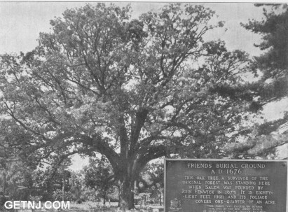
The Plaque Reads:
Friends Burial Ground
A.D. 1676
This Oak Tree, A Survivor of the Original Forest, Was Standing Here When Salem was Founded by John Fenwick in 1675. It is Eighty-eight Feet High and Its Foliage Covers One-quarter of an Acre
"This Tablet Was Erected on October 10th, 1925 by the New Jersey Society of Pennsylvania on the Quarter Millennial Anniversary of the Founding of Salem"
Points of interest:
|
The Historic Roadsides in New Jersey Table of Contents |
|
|
UrbanTimes.com |